


 del.icio.us
 blinklist
 digg
digg Facebook
 Furl
Furl ma.gnolia
 Newsvine
 Pownce
 reddit
 StumbleUpon
 Technorati
 Twitter
We take a look at hiking in the Amazon, swimming robots, Lunar images, Martian weather, Apollo sites, Space Station precautions, viewer feedback, and as always take a peek back into history and up in the sky this week.
Direct Download:
MP3 Download | Ogg Download | HD Video | Mobile Video | YouTube
RSS Feeds:
MP3 Feed | Ogg Feed | iTunes Feed | HD Feed | Mobile Feed | Tablet Feed
Support the Show:
|
Show Notes:
Hiking the Amazon

- The low down
- The project began about two years ago and became available on Wed 21
- August of 2011, a few members of the Brazil and U.S. Street View and Google Earth Outreach teams were invited to the Amazon Basin to collect ground-level images of the rivers, forest and communities in the Rio Negro Reserve.
- Significance
- The goal of the project was to capture a 50-kilometer (30-mile) stretch of the Rio Negro, a local team will continue the mission getting more images, with the possibility of maybe having the whole basin mapped
- Pictures were taken along the Rio Negro in Brazil last year using camera-mounted three wheeled bicycles that have cameras that continuously snap images in every direction.
- 500,000 still photos were used for the project
- Of Note
- Images include the largest community in the Rio Negro Reserve, and other communities along the river
- The project was made possible in partnership with the Amazonas Sustainable Foundation (FAS), the local nonprofit conservation organization.
- Street View Highlights
- Amazon forest trail
- Main Section of the Rio NEgro river
- Smaller tributaries where the forest is flooded
- Tumbira, Images the largest community in the Rio Negro Reserve
- Where Brazil nuts are harvested
- And even forest animals
- Multimedia
- YouTube VIDEO :Tour the Amazon with Street View
- IMAGE GALLERY: Google maps Street View
- Further Reading / In the News
- Visit the Amazon on World Forest Day with Street View @ Google Official Blog
- Google opens Amazon wilds to armchair explorers @ SpaceDaily.com
- Google brings Brazil’s Amazon forest to Street View @ news.Cnet.com
*— NEWS BYTE — *
Robotic Jellyfish
- The low down
- American researchers have created a robotic jellyfish, constructed from a set of smart materials named Robojelly
- Its characteristics could make it ideal to use in underwater search and rescue operations
- The simply swimming action of the jellyfish makes it an ideal invertebrate to base a vehicle on
- The smart materials offer the ability to change shape or size as a result of a stimulus, and carbon nanotubes
- Significance
- This prototype used commercially-available shape memory alloys that “remember” their original shape
- They then coated those with carbon nanotubes and coated with a platinum black powder.
- The robot is powered by heat-producing chemical reactions between the oxygen and hydrogen in water and the platinum on its surface
- Heat given off from the reaction transfers to the artificial muscles in the robot allowing the robot to transform into different shapes
- The RoboJelly still needs development to achieve full functionality and efficiency
- Robots of the floating kind
- Another interesting robot is a quasi-autonomous floating robot
- It is made to land on a lake, propel itself around and gather data about the water and atmosphere as it goes
- The robot itself weighs about 100 pounds, and carry 150 pounds’ worth of sensing equipment
- In a video it can turn circles and navigate around a lake
- Currently it can be controlled from anywhere around the world using an Internet connection
- The team is however working on making it more autonomous, even have a sense of curiosity to better investigate certain places
- This type of robot would be useful science and military missions on Earth or for extraterrestrial lake landing probes, like Titan
- It could also be used for help officials survey the cleanup of dangerously polluted water in munitions dumps and mines
- Multimedia
- YouTube VIDEO : Bioinspired Robojelly fuelled by hydrogen
- YouTube VIDEO : Moon Jellyfish at the Vancouver Aquarium
- YouTube VIDEO : Wolfgang Fink’s Robotic Lake Lander
- Further Reading / In the News
- Jellyfish inspires latest ocean-powered robot (w/ video) @ physorg.com
- Jellyfish-like Robot Takes a Very Simple Swim @ pcmag.com
- Robojelly: Hydrogen-powered robot jellyfish is squishy awesome @ news.cnet.com
- Self-Propelled Floating Robot Could Explore Saturn Moon Titan @ space.com
*— TWO-BYTE NEWS — *
First MoonKAM Image comes in from the Lunar Orbiters Ebb & Flow
- Last Time on SciByte
- Exoplanets & Social Media | SciByte 29 (Jan 17, 2012) – GRAIL moon probes names finally named
- Revisiting the Moon | SciByte 27 (Jan 5, 27, 2012) – Moon meets GRAIL (Gravity Recovery And Interior Laboratory)
- The low down
- The first student chosen image has been released from the MoonKAM Imager on the Lunar Mapping orbiters – Ebb & Flow
- The image taken this last week was of the far side of the lunar surface, with Earth in the background
- Further Reading / In the News
- NASA’S Grail MoonKam Returns First Student-Selected Lunar Images @ NASA.gov
- 1st Student Selected MoonKAM Pictures Look Inspiringly Home to Earth @ UniverseToday.com
Martian Clouds

- The low down
- The Mars Reconnaissance Orbiter has been in orbit around Mars since March of 2006
- Recently is was looking for seasonal changes as spring is now arriving on the Red Planet’s northern hemisphere, unfortunately it was a cloudy day
- Significance
- The dunes have a coating of CO2 ice sublimating away under the increasingly stronger suns rays
- The clouds themselves are likely made up of water ice crystals
- In the Martian winter the dunes seen in the image are completely covered with carbon dioxide ice
- Of Note
- The research team will continue to check back on this region so it can continue to provide a seasonal portfolio of the site
- Multimedia
- IMAGE : A Cloudy Day On Mars; credit : hirise.lpl.arizona.edu
- Further Reading / In the News
- HiRISE – High Resolution Imaging Science Experiment
- A Cloudy Day @ hirise.lpl.arizona.edu
- Clouds Get in the Way on Mars @ universetoday.com
Apollo landing sites up close

- Last time on SciByte
- Solar Storms & Higgs Boson | SciByte 37 (Mar 13, 2012) : VIEWER FEEDBACK : Archeology in Space
- The low down
- The new pictures are of the Apollo 17, Apollo 14, and Apollo 12 landing sites
- These new high-resolution images were taken while LRO was in what’s referred to as a “dipping orbit,” where the spacecraft was roughly 13 miles [21 km] above the surface
- Image of the Apollo 11 landing site captured from 15mi [24 km] above the surface provides LRO’s best look yet at humanity’s first venture to another world
- Significance
- The Apollo 11 image shows the Lunar Module’s descent stage, a seismic experiment monitor, a laser ranging reflector (LRRR, still used today to measure distances between Earth and the Moon) and its cover, and a camera can be discerned in the overhead image
- Visible around all Apollo landing sites are dark trails where astronauts or lunar rovers went.
- Of Note
- The lower orbit imaging was able to get 6in [15cm] to every pixel
- Images from an altitude of only 15 miles [24km] offered the highest-resolutions yet of Apollo 11
- An often asked questions is if you can see if the flags are still there, given the heat/cold cycle and UV environment will degrade the nylon,
- Multimedia
- YouTube VIDEO : LRO Revisits Apollo Landing Sites
- NASA Spacecraft Images Offer Sharper Views of Apollo Landing Sites @ NASA.gov
- Apollo Landing Sites Revisited Image Gallery
- Further Reading / In the News
- Apollo 12: Pinpoint Landing on the Ocean of Storms @ NASA.gov
- Look, It’s a Moon Buggy! LRO’s Best Look Ever at the Apollo 15 Landing Site @ UniverseToday.com
- NASA Releases Closer Looks at Apollo Landing Sites from the Lunar Reconnaissance Orbiter @ UniverseToday.com
- Apollo 11: ‘A stark beauty all its own’ @ UniverseToday.com
- Best Views Yet of Historic Apollo Landing Sites @ UniverseToday.com
Space Station takes precautionary shelter
- The low down
- On the morning of March 24, the six member crew of the space station took precautionary shelter in their respective Soyuz vehicles when a piece of debris passed within 14 mi [23km] of the station
- This is only the third time a crew has had to seek shelter in the Soyuz vehicles.
- The piece was a remnant of a collision between the dormant Cosmos 2251 satellite and an operational Iridium 33 communications satellite in 2009 that added about 2,000 trackable items to the orbital debris catalog.
- The other two precautionary shelter events were March 12, 2009 and June 28, 2011
- In the 2011 incident a piece of space junk passed within just 820 ft [250 m] of the station.
- Further Reading / In the News
- ISS On-Orbit Status 03/24/12 @ nasa.com
- ISS crew takes shelter to avoid passing space junk @ physorg.com
- Space Junk Forces Station Astronauts to Take Shelter in Lifeboats @ space.com
*— Updates — *
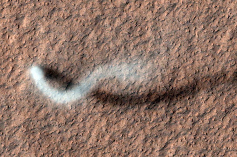
Martian Storm Chasing
- Last time on SciByte
- Solar Storms & Higgs Boson | SciByte 37 (Mar 13, 2012) : Martian Dust Devil
- The low down
- The Mars Reconnaissance Orbiter has been examining Mars with six science instruments since 2006
- Mars orbiters, rovers and landers have all captured devils in action before
- A towering dust devil, casts a serpentine shadow over the Martian surface in an image acquired by the High Resolution Imaging
- Significance
- It lofted a twisting column of dust more than half a mile [800 meters] high, and had approximately a 90ft [30 yards] radius Science Experiment (HiRISE) camera on NASA’s Mars Reconnaissance Orbiter
- NASA scientists have used the high resolution images to create a 3D image of the dust devil
- Using the sizing information gleaned from the image, and calculating based off of the shadow they were able to project a three dimensional model
- Multimedia
- YouTube VIDEO : Storm Chaser on Mars
- Social Media
- HiRISE @HiRISE
- Further Reading / In the News
- Huge Dust Devil on Mars Captured in Action @ UniverseToday.com
- Mars orbiter catches twister in action @ PhysOrg.com
- Photo from NASA Mars orbiter shows wind’s handiwork (Jan 2012) @ PhysOrg.com
*— VIEWER FEEDBACK — *
Ocean Salinity


- Thanks to Mrs. Grubb’s Class’ science
- Asked about the word for when you can’t dissolve any more of a substance into water
- Also asked about the oceans salinity content across the oceans, and the locations of the saltiest places.
- Saturation Point
- Compounds that are called insoluble means they have poor or very poor solubility
- When the solution can no longer dissolve or break down the bonds of a solute, it is called the saturation point
- The saturation point, maximum concentration of a solution, can change with temperature, pressure and the chemical properties of molecules in the solution
- There are also rare instances of molecules that don’t have a saturation point, they are called fully miscible
- Supersaturation
- Under the right conditions you can actually exceed the saturation point, like carbonated water or soda pop.
- They are filled under higher than atmospheric pressure, so when you open it and the pressure drops the carbon dioxide in the water escapes the solution
- Supersaturated solutions of sugar and water are sometimes used to make rock candy
- The Oceans salinity
- The salinity levels of the ocean are different all over the world and interact with the oceans flow
- Changes in salt concentration at the ocean surface affect the weight of surface waters. Fresh water is light and floats on the surface, while salty water is heavy and sinks
- Saltiest bodies of water
- Don Juan Pond in Victoria Land, Antarctica. At a possible 18 times the salinity of the ocean, Don Juan never freezes.
- Lake Assal (Djibouti) in central-eastern Djibouti, Garabogazkol in Turkmenistan, and the Dead Sea on the border of Jordan and Israel
- Multimedia
- YouTube VIDEO :
- IMAGE GALLERY: @
- IMAGE : @
- Further Reading / In the News
- Salinity @ NASA.gov
SCIENCE CALENDER
Looking back
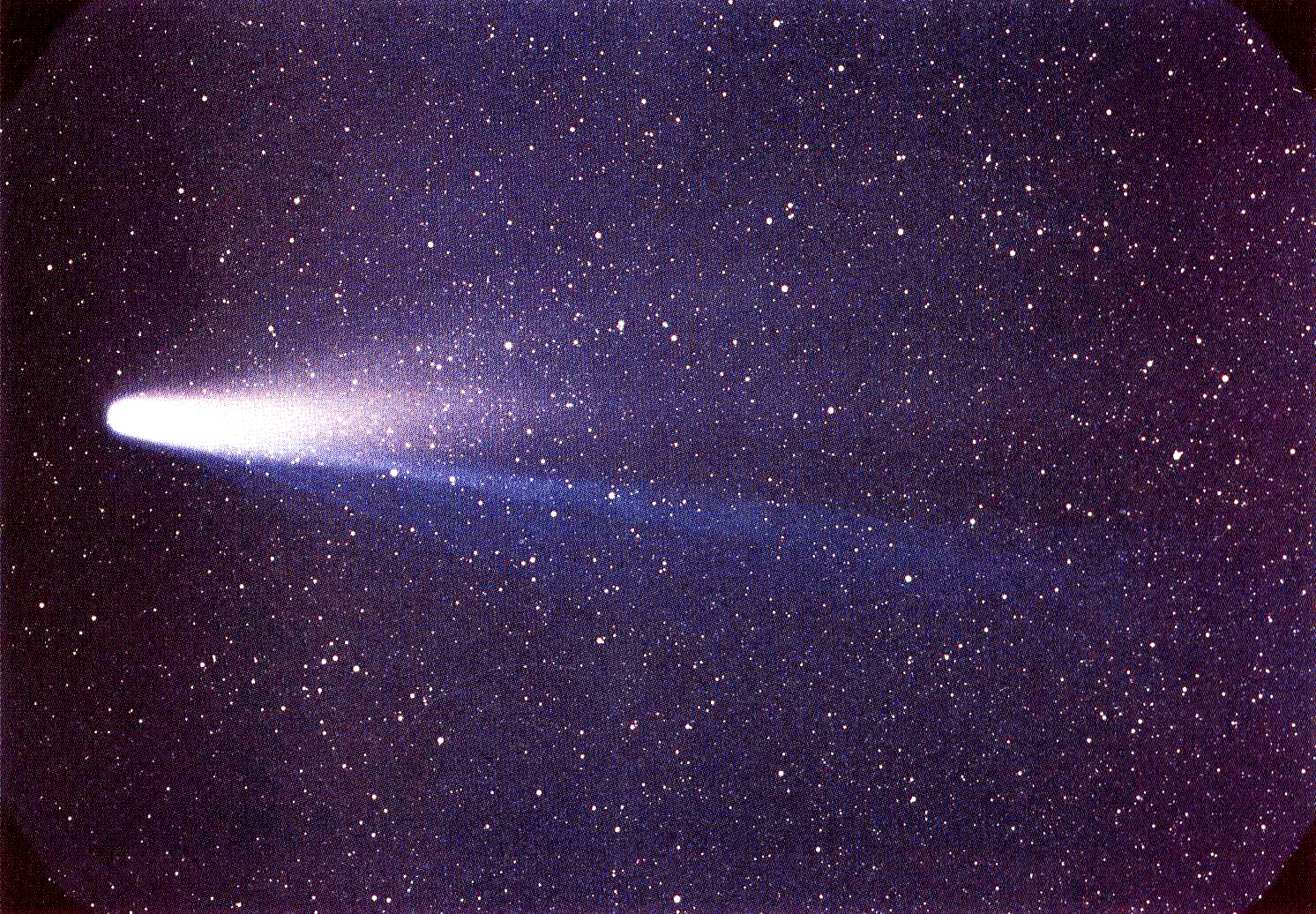
- Mar 30, 239 BC : 2251 years ago : Halley’s Comet : In 239, B.C., was the first recorded perihelion passage of Halley’s Comet by Chinese astronomers in the Shih Chi and Wen Hsien Thung Khao chronicles. Its highly elliptical, 75-year orbit carries it out well beyond the orbit of Neptune and well inside the orbits of Earth and Venus when it swings in around the Sun, travelling in the opposite direction from the revolution of the planets. It was the first comet that was recognized as being periodic. An Englishman, Edmond Halley predicted in 1705 that the comet that appeared over London in 1682 would reappear again in 1759, and that it was the same comet that appeared in 1607 and 1531. When the comet did in fact reappear again in 1759, as correctly predicted, it was named (posthumously) after Halley | Comet Halley | Comet Halley @ astropix.com | Reproduction of original plates of Comet Halley 25 May 1910 @ esa.int |
- Mar 31, 1889 : 123 years ago : Eiffel Tower : In 1889, the Eiffel Tower, Paris, France, was inaugurated, becoming the world’s tallest tower of its era. With a height of 300-m (986-ft), it remained the world’s tallest structure until surpassed by the Empire State Building, 40 years later. The designer Gustave Eiffel, 56, celebrated by unfurling a French flag at the top of the tower. The immense iron latticework design was chosen unanimously from 700 proposals submitted in a competition. Construction took from 26 Jan 1887 to 31 Mar 1889, using 300 steel workers. It was erected for the Paris Exposition of 1889, which had 1,968,287 visitors. Elevators were powered from machinery in the basements of the eastern and western pillars | Record breaking structure | Stages of Construction | This Day in History @ 32s |
Looking up this week

-
Keep an eye out for …
+Thursday, Mar 29 : Sirius is in the S-SE in early evening
+Friday, Mar 30 : first quarter moon, Mars in high in the E at nightfall climbing across the sky and setting at first light, summer starts in the Northern hemisphere of Mars -
More on what’s in the sky this week
-
Constellations of the Southern Hemisphere : astronomyonline.org